MIPFly One
A flight instrument born from the combined love of flight and electronics. Designed with openness and expandability in mind, as one instrument for a large range of pilots.
Scroll to interact with the model
MipFly One – Your First Step into Soaring Innovation
EMipFly One brings simplicity and reliability together for pilots who demand performance without compromise. Explore the technical foundation that makes it the perfect entry into the MipFly experience.
High-Contrast Display
Equipped with a 4.4" monochrome LCD (320x240), the MipFly One offers exceptional sunlight readability and a 20 fps refresh rate, ensuring clear visibility in all lighting conditions.
Dual-Core Processing Power
Powered by a dual-core Allwinner A20 processor running at ~1GHz per core, complemented by a 72 MHz Cortex-M3 real-time coprocessor for efficient multitasking and sensor data processing.
Advanced Sensor Suite
Features dual high-precision pressure sensors, a 3-axis accelerometer, gyroscope, and magnetometer, delivering responsive and accurate vario readings with real-time sensor fusion.
High-Sensitivity GPS
Utilizes the Ublox M8N GPS receiver with a ceramic patch antenna, supporting concurrent reception of up to 3 GNSS systems (GPS, Galileo, GLONASS, BeiDou) for precise positioning.
Extensive Battery Life
Equipped with a 7200 mAh lithium-ion battery, the MipFly One offers up to 16 hours of continuous operation, ensuring reliability during extended flights.
Customizable Audio Alerts
Offers fully configurable vario sounds, including frequency, tone, and interval settings, with options for square or sine wave outputs to suit pilot preferences.
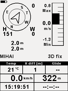
Comprehensive Navigation Tools
Includes detailed maps, airspace alerts, wind direction and speed indicators, thermal assistance, and task navigation features for cross-country flights.
Connectivity Options
Standard Bluetooth module included, with options to upgrade to Wi-Fi via internal USB port, facilitating data synchronization and live tracking capabilities.
USB-OTG Functionality
Features a full-size USB port supporting On-The-Go (OTG) for charging, data transfer, firmware updates, and peripheral connectivity without the need for additional drivers.
General Interface Features
Customizable Interface
User definable pages with configurable graphical elements (size, position, zoom level etc.)
Multi-lingual
Multi-lingual interface to support pilots from around the world
Audio Alerts
Customizable audio alerts to keep you informed during flight
Display Options
Black on white or white on black user interface to adapt to different lighting conditions
Memory Features
- 3D flight logger IGC format
- Practically more memory for flights than anyone can use in a lifetime
Task Navigation
- Intuitive and easy to use task interface
- Task optimisation and waypoint data aproximation algorithm
- Waypoint navigation for freeflight
- Easy waypoint importing in GPSDump format
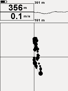
Variometer/Altimeter Features
High-precision sensors for accurate readings in all conditions.
- Dual high precision pressure sensor interlaced reading for high precision and high rate of response to vertical speed
- Selectable instant vario function using accelerometer
- Configurable vario digital filter and integration values for analog and digital (average) vario
- Fully configurable Vario Sound (frequency, increments, frequency/vertical speed relation,...)
- Square wave or sine wave tone
- Multiple independent altimeters (QNH, GPS, AGL, difference from takeoff etc.)
- Worldwide altitude data for AGL calculation
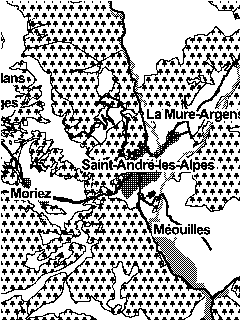
Maps & 3D Airspace
Comprehensive mapping system to keep you aware of your surroundings.
- Detailed maps representing woods, settlements + names and water surfaces for better orientation
- Two levels of zoom for graphical maps
- Compatible with Open Air format (copy required airspace to SD and select it from the menu)
- Graphical representation of the airspace map and name of violated airspace
- Configurable warning distances for vertical and horizontal airspace distance
- List containing near and violated airspaces (AGL defined airspaces are considered violated based only on horizontal positioning)
Download additional maps for your region from our downloads section.
Cross Country Features
Advanced tools to help you maximize your cross country performance.
- Extremely precise and prompt wind algorithm (no spiraling required)
- Intuitive and large wind direction indication
- Distance and direction to last thermal
- Intuitive thermal graph for centering aid
- Distance and angle from takeoff
- Glide ratio indicator